


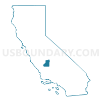
Kings County--Hanford City PUMA, California
About
Outline

Summary
| Unique Area Identifier | 192261 |
| Name | Kings County--Hanford City PUMA |
| State | California |
| Area (square miles) | 1,391.53 |
| Land Area (square miles) | 1,389.42 |
| Water Area (square miles) | 2.11 |
| % of Land Area | 99.85 |
| % of Water Area | 0.15 |
| Latitude of the Internal Point | 36.07247800 |
| Longtitude of the Internal Point | -119.81553010 |
Maps

Graphs
Select a template below for downloading or customizing gragh for Kings County--Hanford City PUMA, California


Neighbors
Neighoring Public Use Microdata Area (by Name) Neighboring Public Use Microdata Area on the Map
- Fresno County (East)--Sanger, Reedley & Parlier Cities PUMA, CA
- Fresno County (West)--Selma, Kerman & Coalinga Cities PUMA, CA
- Kern County (West)--Delano, Wasco & Shafter Cities PUMA, CA
- Monterey (South & East) & San Benito Counties PUMA, CA
- San Luis Obispo County (East)--Inland Region PUMA, CA
- Tulare County (Northwest)--Visalia City PUMA, CA
- Tulare County (Outside Visalia, Tulare & Porterville Cities) PUMA, CA
- Tulare County (West Central)--Tulare & Porterville Cities PUMA, CA
Top 10 Neighboring County (by Population) Neighboring County on the Map
- Fresno County, CA (930,450)
- Kern County, CA (839,631)
- Tulare County, CA (442,179)
- Monterey County, CA (415,057)
- San Luis Obispo County, CA (269,637)
- Kings County, CA (152,982)
Top 10 Neighboring County Subdivision (by Population) Neighboring County Subdivision on the Map
- Visalia CCD, Tulare County, CA (135,978)
- Tulare CCD, Tulare County, CA (68,347)
- Hanford CCD, Kings County, CA (67,210)
- Paso Robles CCD, San Luis Obispo County, CA (49,131)
- Lemoore CCD, Kings County, CA (36,350)
- Dinuba CCD, Tulare County, CA (32,456)
- Wasco CCD, Kern County, CA (29,808)
- Coalinga CCD, Fresno County, CA (19,362)
- Stratford CCD, Kings County, CA (16,634)
- Avenal CCD, Kings County, CA (15,565)
Top 10 Neighboring Place (by Population) Neighboring Place on the Map
- Hanford city, CA (53,967)
- Corcoran city, CA (24,813)
- Lemoore city, CA (24,531)
- Avenal city, CA (15,505)
- Lemoore Station CDP, CA (7,438)
- Armona CDP, CA (4,156)
- Laton CDP, CA (1,824)
- Home Garden CDP, CA (1,761)
- Kettleman City CDP, CA (1,439)
- Stratford CDP, CA (1,277)
Top 10 Neighboring Elementary School District (by Population) Neighboring Elementary School District on the Map
- Hanford Elementary School District, CA (44,487)
- Lemoore Union Elementary School District, CA (26,395)
- Kingsburg Joint Union Elementary School District, CA (14,651)
- Pioneer Union Elementary School District, CA (10,921)
- Central Union Elementary School District, CA (10,904)
- Armona Union Elementary School District, CA (6,672)
- Kings River Union Elementary School District, CA (3,224)
- Lost Hills Union Elementary School District, CA (2,747)
- Kings River-Hardwick Union Elementary School District, CA (2,661)
- Lakeside Union Elementary School District, CA (2,591)
Top 10 Neighboring Secondary School District (by Population) Neighboring Secondary School District on the Map
- Tulare Joint Union High School District, CA (78,539)
- Delano Joint Union High School District, CA (70,221)
- Hanford Joint Union High School District, CA (69,767)
- Lemoore Union High School District, CA (38,777)
- Wasco Union High School District, CA (29,934)
- Kingsburg Joint Union High School District, CA (17,503)
Top 10 Neighboring Unified School District (by Population) Neighboring Unified School District on the Map
- Visalia Unified School District, CA (142,596)
- Coalinga-Huron Joint Unified School District, CA (26,275)
- Corcoran Joint Unified School District, CA (26,190)
- Reef-Sunset Unified School District, CA (17,222)
- Riverdale Joint Unified School District, CA (6,108)
- Laton Joint Unified School District, CA (3,727)
- Shandon Joint Unified School District, CA (1,859)
- Alpaugh Unified School District, CA (1,343)
- School District Not Defined, CA (710)
Top 10 Neighboring State Legislative District Lower Chamber (by Population) Neighboring State Legislative District Lower Chamber on the Map
- Assembly District 30, CA (504,729)
- Assembly District 33, CA (469,458)
- Assembly District 28, CA (462,750)
Top 10 Neighboring State Legislative District Upper Chamber (by Population) Neighboring State Legislative District Upper Chamber on the Map
- State Senate District 14, CA (1,020,927)
- State Senate District 16, CA (976,489)
- State Senate District 15, CA (903,066)
Top 10 Neighboring 111th Congressional District (by Population) Neighboring 111th Congressional District on the Map
- Congressional District 22, CA (797,084)
- Congressional District 21, CA (784,176)
- Congressional District 20, CA (744,350)
- Congressional District 17, CA (664,240)
Top 10 Neighboring Census Tract (by Population) Neighboring Census Tract on the Map
- Census Tract 16.02, Kings County, CA (12,118)
- Census Tract 103, San Luis Obispo County, CA (10,043)
- Census Tract 6.01, Kings County, CA (10,021)
- Census Tract 4.04, Kings County, CA (9,791)
- Census Tract 17.01, Kings County, CA (9,142)
- Census Tract 9, Tulare County, CA (8,171)
- Census Tract 9, Kings County, CA (8,057)
- Census Tract 43, Tulare County, CA (7,682)
- Census Tract 3, Kings County, CA (7,446)
- Census Tract 3.01, Tulare County, CA (6,717)
Top 10 Neighboring 5-Digit ZIP Code Tabulation Area (by Population) Neighboring 5-Digit ZIP Code Tabulation Area on the Map
- 93274, CA (69,721)
- 93230, CA (65,264)
- 93291, CA (52,849)
- 93277, CA (50,607)
- 93245, CA (37,412)
- 93662, CA (30,237)
- 93280, CA (27,152)
- 93212, CA (26,079)
- 93210, CA (19,504)
- 93631, CA (15,941)